Isolation Photo Project, Day 120: Red Barn Milk Company

For this project, photography is the fun easy and emotionally rewarding element. The research and preparation are the boring and unrewarding parts.

I’ve come to realise how much work is involved in planning the Barns, Bridges and Buildings project. I’m familiar with the larger Hunterdon County townships such as West Amwell Township and East Amwell Township that are close to where I live in Montgomery Township. To minimise long driving distances on these small county and township road, I have tried mapping out bridges and historic buildings in the Amwells. However, I am frustrated in my efforts to find useful sources of information at the township level.

I have used the links provided in the post, but the information on the National Register of Historic Places and Bridge Hunter is not organised by townships. This makes shot planning much more challenging. I have clicked on link after link, finding subjects that meet my interest only to discover that it’s an hour away, but wondering what else I can photograph to make the long drive worth it.

I am now compiling a list of townships in Hunterdon County to research what significant or historic bridges, barns and buildings might be found in each. The additional challenge will break that township down further to the unincorporated community. For example, in Montgomery Township, there are several historically significant unincorporated communities: Skillman, Belle Mead, Harlingen, Blawenberg and the borough of Rocky Hill. Two of these unincorporated areas have postal zip codes, but postal codes do now map to township borders. Postal codes are for the convenience of the US Postal Service.

Breaking down East Amwell Township, I found the following areas: Ringoes, Werstville, and Amwell.

Photography is the fun, relaxing and emotionally rewarding element of this project. The research and preparation are the tedious and unrewarding parts.

Radius from Montgomery Township

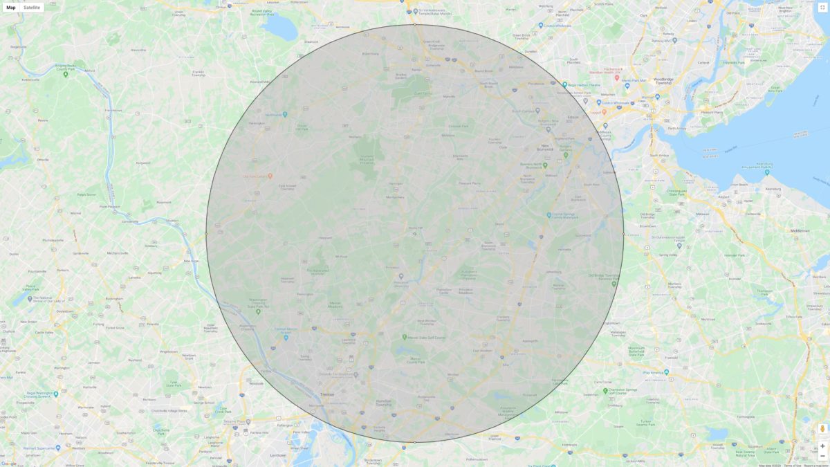
I have decided that the furthest I will drive is thirty minutes or 25km. Based on mapping data, that puts East Amwell, West Amwell, Lambertville, and the lower end of Flemington into range. There are over a dozen, historically significant unincorporated communities within those limits some of which have just one listed historic property. Google Street view along some of the roadways shows what might be other historic buildings, but Google Maps reveals nothing about those buildings. Searching Google has not proved fruitful.

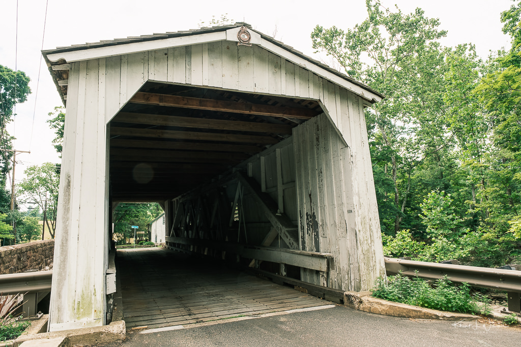
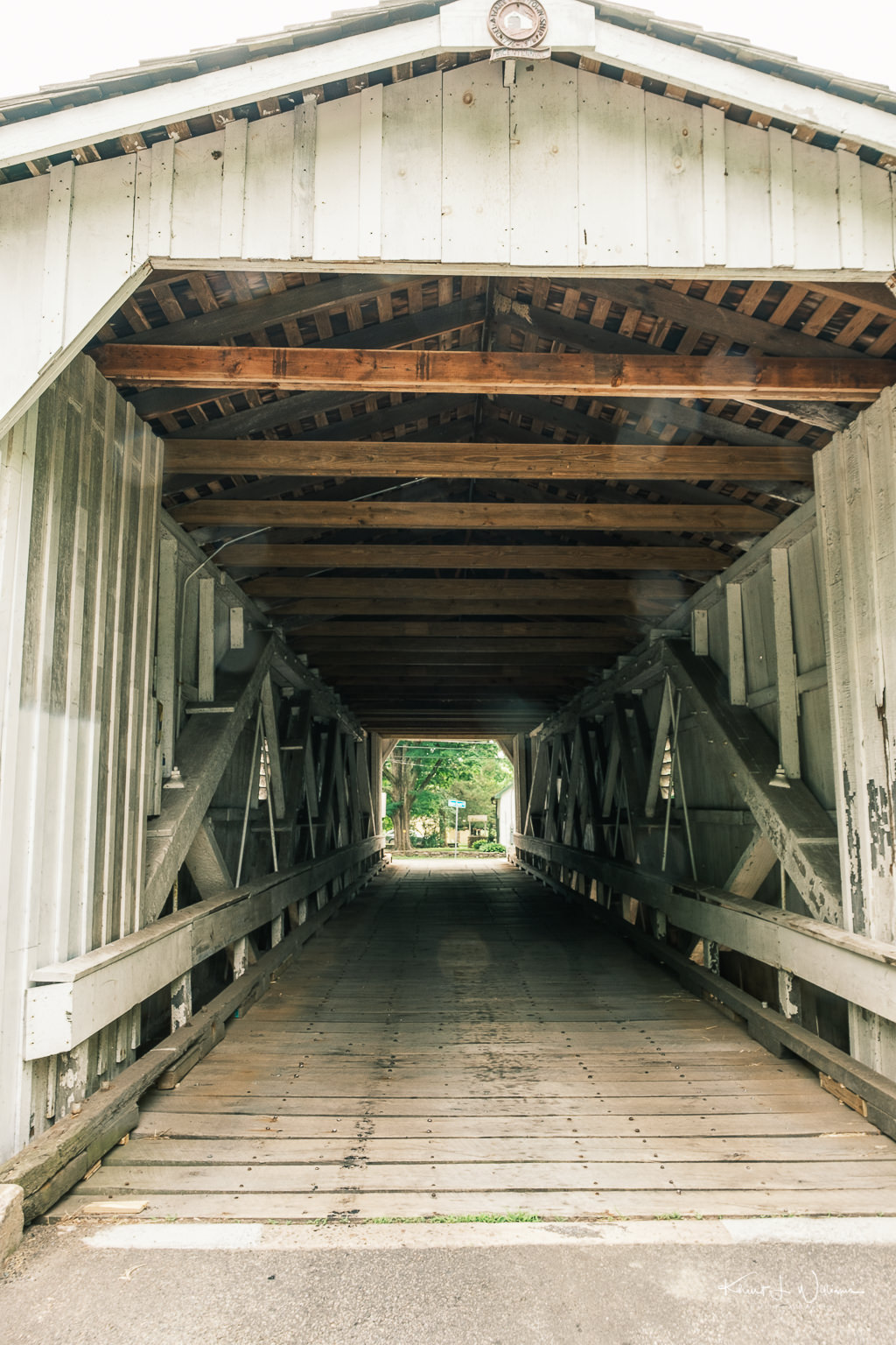
I want more than just a snapshot of the subject. I will need time to walk around the property, looking for interesting angles and points of view. This is necessary to do onsite, as Google Stree View only shows views from the roadway and only at the time of year the Google Maps car drove the road. I have found interesting bridges only to discover via Google Street View that the roadway on either side of the bridge is narrow, street parking is not allowed, and access to the riverbank is impossible without trespassing on a homeowners property. I don't want any interaction with the local police. I guess it's possible to knock on a door, explain the project and hope the homeowner gives permission. But if they do not, the trip has been wasted.

One of the photographers on the project suggested using this letter to get access to tricky locations.

Hello Hunterdon County Neighbor, My name is Lauren and I am part of a select few photographers that are working on a project for the Hunterdon County Chamber of Commerce. We are tasked with taking pictures for our project of "Barns, Bridges and Buildings of Hunterdon County". Every photo submitted becomes part of the archive which will be shared with the Hunterdon Historical Society and be featured in an online gallery. Certain selected outstanding photographs will be recognized and the photos published in the Hunterdon County Chamber of Commerce magazine, “Hunterdon Living” as well as an ebook of selected photos.

Although photos can be taken from public access points such as roads, I would like to obtain your permission to enter your property boundaries in order to take photos from different angles to include ground and aerial perspectives. If you grant permission to allow myself access to your property for this project, can you please fill out the attached form and then contact me so I can follow up with you to arrange pick up of the form and talk with you about and restrictions or concern you may have.

I am unable to guarantee submission of pictures taken on, around, or of your property. However, if a picture is submitted, and selected, I will be happy to provide you a digital copy of the picture selected, along with a limited use and print release form.

Thank you for you're time and consideration of allowing myself access to your property. I am hopeful in being able to include any of your Barns, Buildings and Bridges to this photo project for Hunterdon County.

Very Respectfully, Lauren McCallum-Young My contact information is: Cell: XXX-XXX-XXXX (text or call) Email: XXXXXXXXX

I could modify that to a shorter form that would fit on an index card.

My name is Khürt Williams. I am working on a project for the Hunterdon County Chamber of Commerce and The Photographers Group. Our goal is to photograph the "Barns, Bridges and Buildings of Hunterdon County" for inclusion into a historical archive. May I have your permission to access your property boundaries in order to take photos from different angles? Cell: 609.865.3380, email: khurt@islandinthenet.com

I had hoped to the website of the East Amwell Historical Society as a starting point for information, but other than Clawson House, I found no useful information. The website mentioned several historic buildings such as Peacock’s General Store in Wertsville, Van Lieu’s General Store, and a few churches and schools some of which were destroyed, and one which is now a house. I could find no addresses for any of these buildings.

There is so little information available from a Google Search that when I type in Ringoes, New Jersey or Wertsville, New Jersey, I get one Wikipedia link with nothing but links to real estate listings for the remainder of the page. Google Street view for Historic Wertsville is utterly useless. In desperation, I have now taken up skimming through Google Map's Satellite view of East Amwell Township hoping to find that needle in a haystack.

Even though I did not know it at the time, I have driven through Historic Rocktown on way to the Prydes Point Trailhead. Historic Rocktown is a 25-minute drive from my home. I noticed the older looking buildings and country home along Rocktown Mill Road but I found no information regarding what these buildings are/were. There is also no parking on the narrow Rocktown Mill Road making photography challenging.

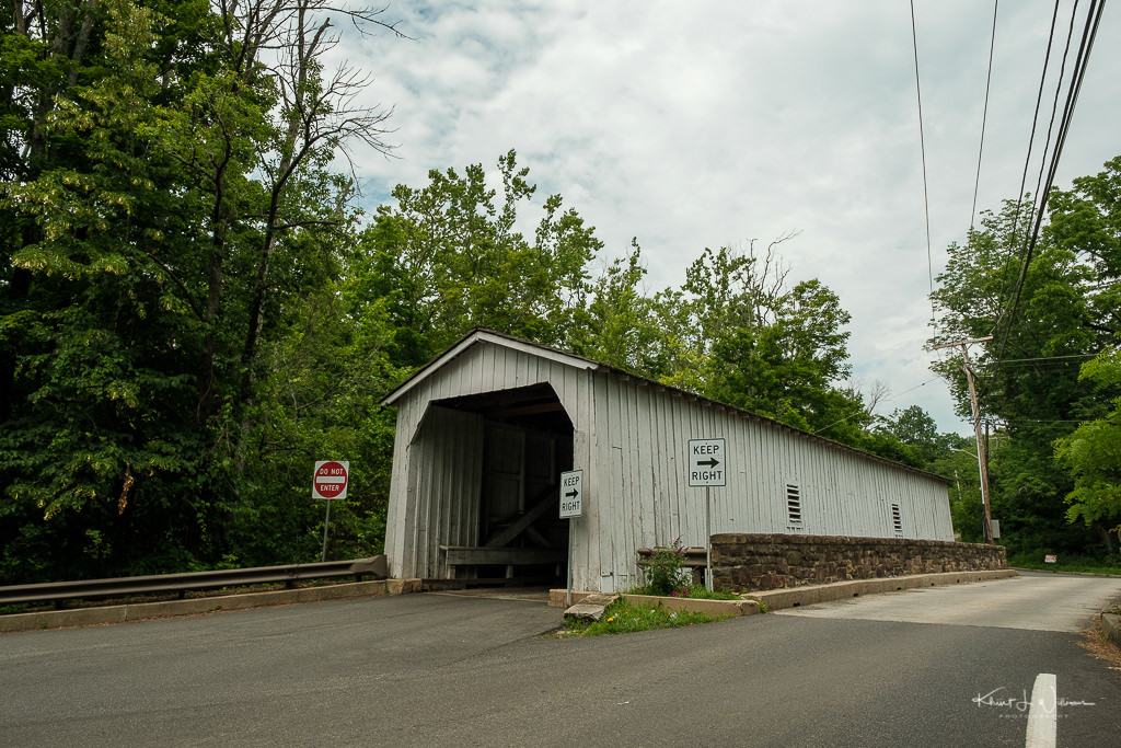
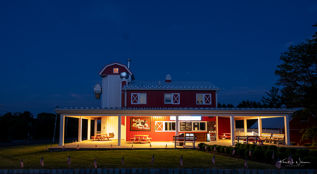
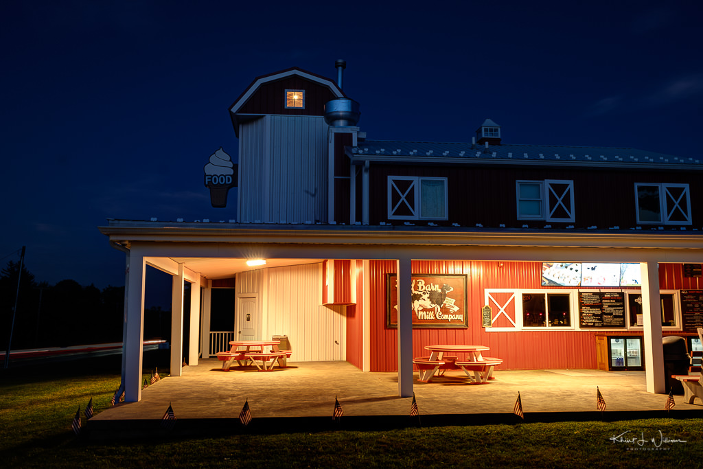
It has been especially challenging finding barns to photograph. Short of driving aimlessly around Hunterdon County, I have no plan.

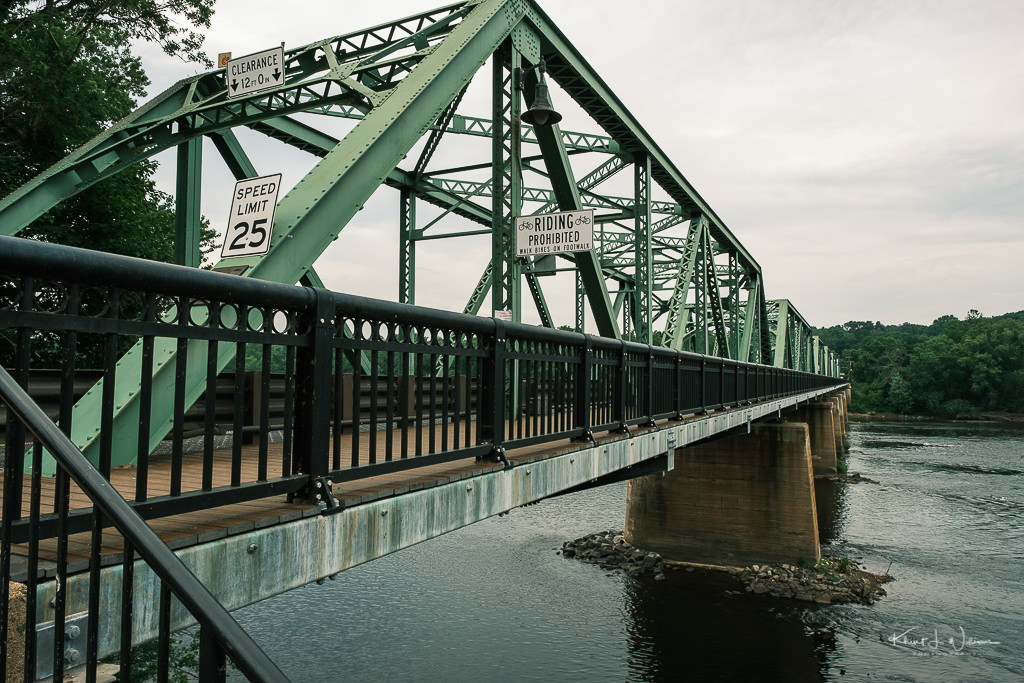
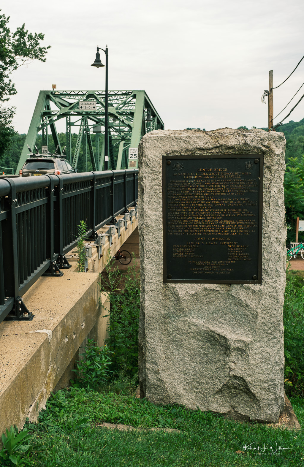
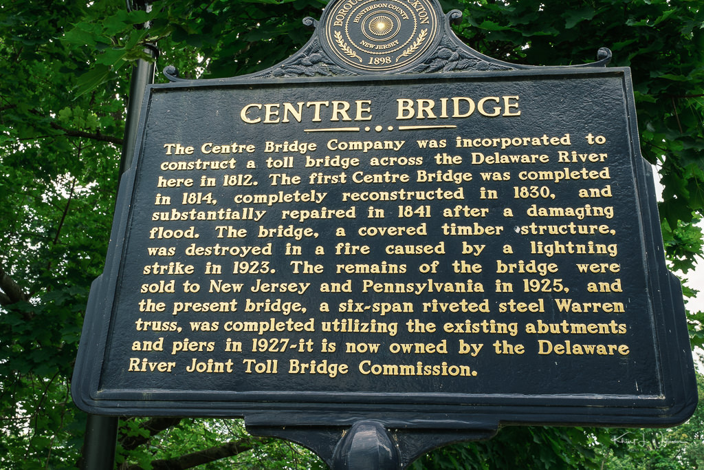
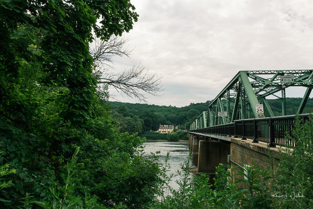
The town of Lambertville is just beyond the 25km radius I set for myself. However, it is full of photographic opportunities; assuming I could find an evening or weekend when the streets are empty of visitors and shoppers.

Red Barn Milk Company | Monday 20 July, 2020 | Day 120 | FujiFilm X-T2 | XF16-55mmF2.8 R LM WR

While the project is a worthwhile effort, I think that the time frame is much too short for me to effectively research each town, find buildings, barns, and bridges of interest, plan the shot by the time of day (golden hour, blue hour) I think is appropriate, figure out the how and where to park, scout the location in person, and photograph the subject. In my experience, these types of projects are multiyear endeavours which require multiple visits to the same location.

All of this will limit the scope of what I can accomplish before the July and August deadlines. Am I overthinking this? Is the goal to photograph "recognizable" barns, bridges and building or just photograph whatever you find whether you know what's in the photograph?

Red Barn Milk Company | Monday 20 July, 2020 | Day 120 | FujiFilm X-T2 | XF16-55mmF2.8 R LM WR

Submitted as part of the 100DaysToOffload project.

Isolation Photo Project, Day 103: Hunterdon County Bridges

I went on a mini-adventure this afternoon, in search of historic bridges in Hunterdon County.

I went on a mini-adventure this afternoon, in search of historic bridges in Hunterdon County. Amateur and professional photographers from all of New Jersey and surrounding areas are invited to participate in the Hunterdon Barns, Bridges and Buildings Photo Project, jointly sponsored by the Hunterdon County Chamber of Commerce and The Photographers Group.

The idea is for photographers to offer their vision of the built environment in Hunterdon and document what they see during the summer of 2020. Hunterdon has its own unique character that can be seen in not only its landscapes but also in its structures, including barns, bridges, churches, commercial buildings and other iconic locations.

I have photographed some of the areas in Hunterdon over the year but recently have a focus on visiting some of the farms and preserver along the Hunterdon 579 Trail. This project is an opportunity to focus my photography on some of the historical architecture of Hunterdon County.

On my shot-list for the day was the Centre Bridge-Stockton Bridge that spans the Delaware River between Stockton in Delaware Township and Centre Bridge in Solebury Township, Bucks County, Pennsylvania and the Lumberville-Raven Rock Bridge on Bulls Island that spans the Delaware River near Raven Rock in Delaware Township New Jersey to Lumberville, Solebury Township in Bucks County, Pennsylvania.

These two bridges are just a fifteen-minute drive between locations. I had expected to photograph each bridge for about 30-45 minutes. As both of these bridges have walkways, I had hoped to shoot primarily from the Pennsylvania side of the river bank.

Arriving at the Bull's Island Recreation Area near Raven Rock, I noticed the entrance was blocked with a sign indicating the lot was full. When I see a park with so many cars, even if there is still some parking available, I won't enter. It is impossible to properly social distance with that many people walking about on the narrow bridge walkway.

I turned around and drove into Stockton, parked outside the Stockton Market and walked to the Centre Bridge-Stockton Bridge. On this very muggy afternoon, only a few pedestrians were walking about in Stockton. By social distancing and a wearing a mask I felt safe, but I noted that only a few of the people I encountered wore masks. Tsk tsk.

Centre Bridge-Stockton Bridge | Friday 3 July, 2020 | Day 103 | FujiFilm X-T4 | XF16-55mmF2.8 R LM WR

According to a plaque on the Pennsylvania side of the bridge, the town of Centre Bridge is so named because it is about midway between Lambertville and Lumberville. I walked over to Centre Bridge and photographed the bridge from the Delaware Towpath. I looked for a way down to the riverbank, but I did not see a way through the thick plant growth and because I was wearing shorts and a t-shirt I was not adequately dressed for bushwhacking. The heat and humidity wore me down, and after just a few photographs, I returned to my parking spot outside the Stockton Market.

Centre Bridge-Stockton Bridge | Friday 3 July, 2020 | Day 103 | FujiFilm X-T4 | XF16-55mmF2.8 R LM WR

I left Stockton and returned to Bull's Island Recreation Area hoping that the parking lot had thinned out. I was disappointed. The lot was still full.

Part of my plan was to end my trip at Conclave Brewing. I had pre-ordered some cans of Moonwater, but the curbside pickup started at 3 PM (or so I thought), and it was only 2 PM.

I remembered that I had passed a sign for Federal Twist Winery. The winery was on my Hunter 579 Trail list, and I hoped I could tour the property and buy some wine.

However, I had more disappointment. The winery was not open for tours. The owners set up a roadside tent near the winery entrance to sell wine and cheese, but I was not allowed to roam the property. I bought a brick of peppery cheddar and a bottle of Rosé made from Chambourcin grapes. Having more time to kill, I continued along the narrow country roads from Federal Twist Raod taking a right turn onto Raven Rock Road and unintentionally ended up at the Lockatong River Bridge.

The Lockatong River Bridge on Raven Rock Road | Friday 3 July, 2020 | Day 103 | FujiFilm X-T4 | XF16-55mmF2.8 R LM WR

Lambertville Iron Works built the Lockatong Bridge in 1878.

The Lockatong River Bridge on Raven Rock Road | Friday 3 July, 2020 | Day 103 | FujiFilm X-T4 | XF16-55mmF2.8 R LM WR

This notice appeared in the Hunterdon Republican on 1 November 1877:

The Committee appointed by the Board of Chosen Freeholders of the county of Hunterdon for the erection of an Iron Bridge over the Lackatong Creek in the township of Delaware will receive proposals at the hotel of Sutton Hockenberry at Stockton for the erection of the said bridge, until Thursday, the 8th day of November, 1877, at 12 o’clock noon of said day.

The Bridge to be of all Wrought Iron, extreme length between abutments, one hundred and twenty-five (125) feet. The roadway to be sixteen (16) feet in the clear, planked with good White Oak Plank, 3 inches thick, clear of wane edge or sap. The Bridge to be built with a factor of four (4) for safety, proportioned to carry a distributive load of one hundred tons in addition to its own weight.

I looked for a path down to the river's edge, but the area was overgrown with brush and wearing just shorts and a t-shirt I risked deer ticks.

From The Lockatong River Bridge, I continued my drive to Conclave Brewing. But after another 15 minutes drive, I arrived unexpectedly at Green Sergeant Covered Bridge, another one of the bridges that were on my to-do list for Saturday.

Green Sergeant Covered Bridge | Friday 3 July, 2020 | Day 103 | FujiFilm X-T4 | XF16-55mmF2.8 R LM WR

Green Sergeant's Covered Bridge is a wooden covered bridge over the Wickecheoke Creek near the border between the Hunterdon Plateau and Amwell Valley located in Delaware Township, Hunterdon County, New Jersey, United States. As the last historic covered bridge in the state of New Jersey, it is listed on the National Register of Historic Places (the Scarborough Bridge in Cherry Hill is the only other covered bridge in New Jersey). The bridge was first constructed in 1872, but after being damaged in 1960, it was dismantled and replaced with a modern bridge. In 1961, due to public outcry, the bridge was rebuilt from the original materials.

Green Sergeant Covered Bridge | Friday 3 July, 2020 | Day 103 | FujiFilm X-T4 | XF16-55mmF2.8 R LM WR

Photographing the bridge was tricky. I could see no obvious way down to the river bank. I stood in the middle of the road near the northern end of the bridge being very careful to look behind me for oncoming traffic.

Green Sergeant Covered Bridge | Friday 3 July, 2020 | Day 103 | FujiFilm X-T4 | XF16-55mmF2.8 R LM WR

I don’t think these are the best photographs of these three bridges. The deadline for submissions is September. I want to return to the bridges in the evening, find a path down to the river banks, and photograph the bridges at golden hour and blue hour.

Submitted as part of the 100DaysToOffload project.